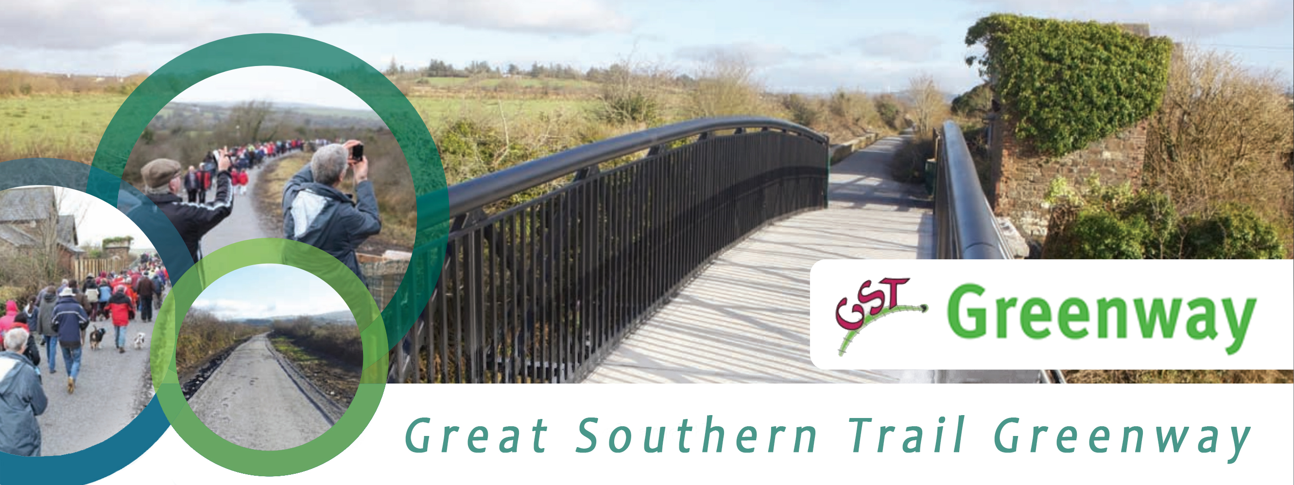
Trail InformationInformation for potential and current users of the trail
The Great
Southern Trail (GST) is a unique 96km (60 miles) stretch of
countryside in West Limerick/North Kerry. It is the route taken
by the Limerick - Tralee/Fenit railway line, which opened in
stages between 1867 and 1887. Most of the route closed between
1975 and 1978 but remains the property of CIÉ ( the National
Transport Company). Much of the development as a recreational
amenity has been undertaken by the GST Ltd. which is a voluntary
group assisted by various Local and State agencies.
Today (May
2012) the GST is suitable for off road walking and cycling along
36km of the Co. Limerick section of the route between Rathkeale
and Abbeyfeale. In Co.Kerry a short stretch has been developed
near the Lartigue Museum in Listowel and work has commenced on
the Tralee-Fenit section.
IRISH
 Síneann
Slí an Mhór-Dheiscirt (GST) feadh 96km(60 míle) trí Iarthar
Luimnigh agus Tuaisceart Chiarraí. Leanann sí líne an iarnróid,
Luimneach – Trá Lí/An Fhianait, a d’oscail i gcéimeanna idir
1867 agus 1887. Dúnadh an chuid is mó den slí idir 1975 agus
1978 ach fós is le CIÉ an líne. Tá Slí an Mhór-Dheiscirt(GST
Ltd), grúpa deonach a fhaigheann cabhair ó ghníomhaireachtaí
Áitiúla agus Stáit, freagrach as an gcuid is mó den bhforbairt
mar áit taitneamhachta. Síneann
Slí an Mhór-Dheiscirt (GST) feadh 96km(60 míle) trí Iarthar
Luimnigh agus Tuaisceart Chiarraí. Leanann sí líne an iarnróid,
Luimneach – Trá Lí/An Fhianait, a d’oscail i gcéimeanna idir
1867 agus 1887. Dúnadh an chuid is mó den slí idir 1975 agus
1978 ach fós is le CIÉ an líne. Tá Slí an Mhór-Dheiscirt(GST
Ltd), grúpa deonach a fhaigheann cabhair ó ghníomhaireachtaí
Áitiúla agus Stáit, freagrach as an gcuid is mó den bhforbairt
mar áit taitneamhachta.
Faoi láthair (Bealtaine 2012) tá an GST in úsáid mar áis
easbhóthair do shiúlóirí agus do rothaithe feadh 39km i gCo.
Luimnigh, idir Ráth Caola agus Mainistir na Féile. I gCo.
Chiarraí tá forbairt déanta ar phíosa gairid in aice le Músaem
Lartigue i Lios Tuathail agus tá obair tosaithe ar an gcuid sin
ó Thrá Lí go dtí An Fhianait.
FRENCH
 Le
Great Southern Trail (GST) traverse sur 96 km une belle région
de l'ouest du comté de Limerick et du nord du comté de Kerry en
République d'Irlande. Le GST n'est autre que le tracé de
l'ancienne ligne ferroviaire Limerick-Tralee/Fenit, ouverte par
étapes entre 1867 et 1887. Pour sa plus grande partie, elle fut
fermée entre 1975 et 1978 mais elle reste toujours la propriété
de la CIÉ, la société nationale des transports. L'essentiel des
aménagements en chemin récréatif a été entrepris par la GST Ltd,
un groupe de volontaires soutenus par diverses agences locales
et nationales. Le
Great Southern Trail (GST) traverse sur 96 km une belle région
de l'ouest du comté de Limerick et du nord du comté de Kerry en
République d'Irlande. Le GST n'est autre que le tracé de
l'ancienne ligne ferroviaire Limerick-Tralee/Fenit, ouverte par
étapes entre 1867 et 1887. Pour sa plus grande partie, elle fut
fermée entre 1975 et 1978 mais elle reste toujours la propriété
de la CIÉ, la société nationale des transports. L'essentiel des
aménagements en chemin récréatif a été entrepris par la GST Ltd,
un groupe de volontaires soutenus par diverses agences locales
et nationales.
À ce jour (mai 2012), le GST est
une voie verte praticable à pied et à vélo sur 36 km dans le
comté de Limerick entre Rathkeale et Abbeyfeale. Dans le comté
de Kerry, une courte section a été aménagée près du musée
ferroviaire de Listowel et les travaux ont commencé sur la
section Tralee-Fenit. [Translation: Gilbert Perrin]
GERMAN
 Der
Great Southern Trail ist eine 96km lange Bahnstrecke in West
Limerick/Nord Kerry. Sie wird von der Limerick - Tralee/Fenit
Railway Line befahren und wurde zwischen 1867 und 1887 eröffnet.
Ein Großteil der Strecke wurde zwischen 1975 und 1978
stillgelegt, verblieb aber im Eigentum des nationalen
Transportunternehmens CIE. Die Weiterentwicklung zu
Freizeitzwecken wurde von der GST Ltd. vorangetrieben – eine
Gruppe von Freiwilligen, die von lokalen und staatlichen
Behörden unterstützt wird. Der
Great Southern Trail ist eine 96km lange Bahnstrecke in West
Limerick/Nord Kerry. Sie wird von der Limerick - Tralee/Fenit
Railway Line befahren und wurde zwischen 1867 und 1887 eröffnet.
Ein Großteil der Strecke wurde zwischen 1975 und 1978
stillgelegt, verblieb aber im Eigentum des nationalen
Transportunternehmens CIE. Die Weiterentwicklung zu
Freizeitzwecken wurde von der GST Ltd. vorangetrieben – eine
Gruppe von Freiwilligen, die von lokalen und staatlichen
Behörden unterstützt wird.
Heute kann der Great Southern
Trail entlang des 36 km langen County Limerick-Abschnitts (zwischen
Rathkeale und Abbeyfeale) zum Wandern und Radfahren genützt
werden. Im Co. Kerry wurde ein kleiner Teil der Strecke in der
Nähe des Lartigue Railway Museums ausgebaut und am Tralee-Fenit-Abschnitt
wurde ebenfalls schon mit der Arbeit begonnen.[Translation:
Thomas Falch]
SPANISH
 El
Great Southern Trail (GST) atraviesa con sus 96 km una bella
región del oeste del condado de Limerick y del norte del condado
de Kerry en la República de Irlanda. El GST aprovecha el trazado
de la antigua línea ferroviaria Limerick-Tralee/Fenit, abierta a
tramos entre 1867 y 1887. La mayor parte del ferrocarril, se
cerró entre 1975 y 1978 pero la CIÉ, empresa pública de
transportes, mantiene su propiedad. La parte fundamental de su
transformación en camino recreativo ha sido realizada por el GST
Ltd, un grupo de voluntarios apoyado por diversas agencias
locales y nacionales. El
Great Southern Trail (GST) atraviesa con sus 96 km una bella
región del oeste del condado de Limerick y del norte del condado
de Kerry en la República de Irlanda. El GST aprovecha el trazado
de la antigua línea ferroviaria Limerick-Tralee/Fenit, abierta a
tramos entre 1867 y 1887. La mayor parte del ferrocarril, se
cerró entre 1975 y 1978 pero la CIÉ, empresa pública de
transportes, mantiene su propiedad. La parte fundamental de su
transformación en camino recreativo ha sido realizada por el GST
Ltd, un grupo de voluntarios apoyado por diversas agencias
locales y nacionales.
En la actualidad (mayo 2012) el
GST es una vía verde para uso de caminantes y ciclistas, de 36
Km en el condado de Limerick entre Rathkeale y Abbeyfeale. En el
condado de Kerry, se ha acondicionado un tramo corto cerca del
museo ferroviario de Listowel y ya han comenzado las obras entre
Tralee-Fenit. [Translation:Mercedes Muñoz Zamora]
POLISH
 The
Great Southern Trail (GST) to odcinek terenu o długości 96 km
(60 mil) w zachodniej części hrabsta Limerick oraz w północnej
części hrabstwa Kerry. Tamtędy właśnie przebiegało połączenie
kolejowe Limerick - Tralee/Fenit, którego odcinki zostały oddane
do użytku w latach 1867 – 1887. Większość trasy została
zamknięta w latach 1975 -1978, ale w dalszym ciągu pozostaje ona
własnością CIÉ (the National Transport Company). Ten teren
został przekształcony w dużej części w teren rekreacyjny przez
GST Ltd., która jest organizacją wolontariacką wspieraną przez
różne lokalne i państwowe instytucje. The
Great Southern Trail (GST) to odcinek terenu o długości 96 km
(60 mil) w zachodniej części hrabsta Limerick oraz w północnej
części hrabstwa Kerry. Tamtędy właśnie przebiegało połączenie
kolejowe Limerick - Tralee/Fenit, którego odcinki zostały oddane
do użytku w latach 1867 – 1887. Większość trasy została
zamknięta w latach 1975 -1978, ale w dalszym ciągu pozostaje ona
własnością CIÉ (the National Transport Company). Ten teren
został przekształcony w dużej części w teren rekreacyjny przez
GST Ltd., która jest organizacją wolontariacką wspieraną przez
różne lokalne i państwowe instytucje.
Obecnie (maj 2012) GST jest
wykorzystywany do spacerów i jazdy rowerem na odcinku o długości
36 km. w hrabstwie Limerick pomiędzy Rathkeale i Abbeyfeale. W
hrabstwie Kerry przekształcono krótki odcinek i rozpoczęto prace
na odcinku Tralee – Fenit. [Translation: Nikola
Sekowska-Moroney]
ITALIAN
 “La
Great Southern Trail (GST) attraversa con i suoi 96 km una bella
regione dell'ovest della contea di Limerick e del nord della
contea di Kerry, in Irlanda. La GST copre il tracciato
dell'antica linea ferroviaria Limerick-Tralee/Fenit, aperta in
varie fasi tra il 1867 e il 1887. La maggior parte del tracciato
fu chiusa tra il 1975 e il 1978 ma la CIE, azienda pubblica dei
trasporti, ne conserva la proprietà. GST Ltd, associazione di
volontariato, si è presa carico di gran parte della sua
trasformazione in percorso ricreativo, con il patrocinio diversi
enti locali e statali. “La
Great Southern Trail (GST) attraversa con i suoi 96 km una bella
regione dell'ovest della contea di Limerick e del nord della
contea di Kerry, in Irlanda. La GST copre il tracciato
dell'antica linea ferroviaria Limerick-Tralee/Fenit, aperta in
varie fasi tra il 1867 e il 1887. La maggior parte del tracciato
fu chiusa tra il 1975 e il 1978 ma la CIE, azienda pubblica dei
trasporti, ne conserva la proprietà. GST Ltd, associazione di
volontariato, si è presa carico di gran parte della sua
trasformazione in percorso ricreativo, con il patrocinio diversi
enti locali e statali.
Attualmente (maggio 2012) la GST è una greenway fruibile a piedi
e in bicicletta per 36 km nella contea di Limerick, tra
Rathkeale e Abbeyfeale. Nella contea di Kerry ne è stato
completato un breve tratto nei pressi del Museo Ferroviario di
Listowel e sono iniziati i lavori sulla tratta Tralee-Fenit.”
[Translation: Giulio Senes]
Trailheads
There are over
twenty access points to the GST from various public roads; these
facilitate locals and those who wish to do loop walks/cycles.
Apart from the entrance at Rathkeale Trailhead all others are to
the north of the N21.
The
principal trailheads are as follows:
-
Rathkeale:
The old station is now the Palatine Museum and is accessed
from the R518 roundabout just south of the N21 and near the
Catholic Church (large spire)
-
Ardagh:
The entrance is at the railway bridge on the local road
L7001 which links the N21 with the R523. Parking is at the
Community Centre 200m from the railway bridge.
-
Newcastle
West: There are two entrances one at Bishop Court (off
Bishop St., town centre) and the other near Gaelscoil Ó
Dóghair/ Recycling Centre on the R521.
-
Barnagh:
This is the summit of the GST and parking is at the N21
westbound lay-by with three options for exploration: a] main
trail west towards Abbeyfeale; b] main trail east towards
Newcastle West/Rathkeale; c] Barnagh railway tunnel 1km
directly from the lay-by
-
Templeglantine: Parking at Halla Inse Bán on the local road
L21006 (directly opposite the Church) ;the trail is 1km
north along this local road.
-
Devon Road: At Devon Road Cross turn north off the N21/R515 junction
and travel along the L7059 where Tullig Wood is clearly
visible to the right.
-
Abbeyfeale: In the town centre turn right from the N21 onto
the R524 (Athea road) where the old Station is on the right
after 1km (adjacent to the 'Railway Bar').
Other information The Southern Trail is generally a Class 2 walking and cycling trail, see tables below. For information on classification and grading for recreational trails go to Irishtrails website http://demo.irishtrails.ie/National_Trails_Office/Publications
|
Rathkeale to Abbeyfeale (Abbeyfeale to Rathkeale) |
|
County:
Limerick |
Category:
Walking/Hiking Trails and Off-Road Cycling Trails |
Type:
Greenway |
|
Length (Kms):
38Km |
Climb (m):
252m |
Grade:
Easy |
Format:
Linear |
|
Estimated time to complete entire trail if walking:
10hr
Estimated time to complete entire trail if cycling:
4hr |
Quality:
*** |
|
Description:
The Southern Trail is generally a Class 2 walking and
cycling trail. While this trail can be cycled - it is
necessary to dismount to open gates along the route.
|
|
Rathkeale to Ardagh (Ardagh to Rathkeale) |
|
County:
Limerick |
Category:
Walking/Hiking Trails and Off-Road Cycling Trails |
Type:
Greenway |
|
Length (Kms):
9Km |
Climb (m):
41m |
Grade:
Easy |
Format:
Linear |
|
Estimated time to complete entire trail if walking:
2hr 10min
Estimated time to complete entire trail if cycling:
52min |
Quality:
*** |
|
Description:
The Southern Trail is generally a Class 2 walking and
cycling trail. While this trail can be cycled - it is
necessary to dismount to open gates along the route.
This is a level section and begins at the Old Station [now the
Palatine Centre; a museum dedicated to the settlers from the
Palatinate in Germany who arrived in Ireland 300 years ago to
escape persecution
www.irishpalatines.org . After a few hundred metres the
River Deel is crossed and then the trail moves to the north of
the N21, crossing the road by means of a riverside underpass.
The westward journey continues through lands associated with the
Palatines. Five beautiful cut-stone overhead bridges are
encountered on the trail to Ardagh. Just before the third one,
on the right, can be seen the ancient Churchyard at Clounagh and
the ruins of 15th Century Lisnacille Castle in the distance. On
the approach to the fourth bridge, about a mile further on, a
local road at a right angle [90 degrees] to the trail leads to
Cahermoyle House (now a private Nursing Home) which has
associations with William Smith O' Brien leader of the 1848
Young Ireland rebellion. The fifth bridge is at Ardagh Station
from where the village, St. Molua's Well and the old fort where
the Ardagh Chalice was found in 1868 can be visited. |
|
Ardagh to Newcastle West (Newcastle West to Ardagh) |
|
County:
Limerick |
Category:
Walking/Hiking Trails and Off-Road Cycling Trails |
Type:
Greenway |
|
Length (Kms):
4Km |
Climb (m):
14m |
Grade:
Easy |
Format:
Linear |
|
Estimated time to complete entire trail if walking:
1hr
Estimated time to complete entire trail if cycling:
24min |
Quality:
*** |
|
Description:
The Southern Trail is generally a Class 2 walking and
cycling trail. While this trail can be cycled - it is
necessary to dismount to open gates along the route.
This section is level at each end with a 'dip' in the middle in
the form of a 1% gradient. It passes through pleasant pastoral
farmland with views of the surrounding hills. As Newcastle West
is approached the River Daar is bridged. 500 metres further on
the R521 is crossed on the level and Newcastle West station is
entered. The only survivors of the railway age are the restored
Station House (private) and the mature oak trees which lined the
approach avenue. |
|
Newcastle West to Barnagh (Barnagh to Newcastle West) |
|
County:
Limerick |
Category:
Walking/Hiking Trails and Off-Road Cycling Trails |
Type:
Greenway |
|
Length (Kms):
10Km |
Climb (m):
110.0 m |
Grade:
Easy |
Format:
Linear |
|
Estimated time to complete entire trail if walking:
2hr 4min
Estimated time to complete entire trail if cycling:
50min |
Quality:
*** |
|
Description:
The Southern Trail is generally a Class 2 walking and
cycling trail. While this trail can be cycled - it is
necessary to dismount to open gates along the route.
This was one of the most arduous challenges in the age of the
steam train as it is an uphill journey for most of the way.
However, the gradients never exceed 2% and the reward for those
continuing westward is that it is downhill all the way from
Barnagh to Abbeyfeale. The trail route is 3Km longer than the
N21 as the train needed a more gentle incline.1Km outside
Newcastle West there is on overhead bridge and then there are
three level crossings giving access to minor roads.7Km from
Newcastle West a quiet road (L1329) comes alongside the trail.
This road climbs into the Rooskagh Hills and is well worth a
visit as it leads to the bog lands and provides wonderful views
of the Limerick Plains and the Golden Vale. It also provides the
opportunity to loop back onto the trail at the aforementioned
level crossings and elsewhere further west. Continuing on the
trail the L1329 is crossed by a high bridge and then Ferguson's
Viaduct is traversed. Shortly after the viaduct the railway was
incorporated into the N21 and now the trail becomes a dedicated
roadside tarmacadam cycleway, with excellent views, for 2Km
before regaining the railway at Barnagh Station. The trains
entered Barnagh Station through a tunnel which can be visited
along a 'stand-alone' 1Km section of the old railway. Access to
the tunnel is from the lay-by at Barnagh on the N21 (Westbound) |
|
Barnagh to Abbeyfeale (Abbeyfeale to Barnagh) |
|
County:
Limerick |
Category:
Walking/Hiking Trails and Off-Road Cycling Trails |
Type:
Greenway |
|
Length (Kms):
15Km |
Climb (m):
27m |
Grade:
Easy |
Format:
Linear |
|
Estimated time to complete entire trail if walking:
3hr 55min
Estimated time to complete entire trail if cycling:
1hr 34min |
Quality:
*** |
|
Description:
The Southern Trail is generally a Class 2 walking and
cycling trail. While this trail can be cycled - it is
necessary to dismount to open gates along the route.
The N21 roadside cycleway continues into a short section of a
cul-de-sac road before the sight of old telegraph poles indicate
that the railway has been regained. This was the western end of
Barnagh Station; the tunnel and railway house are at the far
side of the N21. The route is pleasant passing through cuttings
and embankments and under two stone bridges. The village of
Templeglantine becomes visible on the left and is reached along
the L21006. Templeglantine is a good starting point for a side
trip to Glenquin Castle (restored) [5Km] and Killeedy Castle (ruin)/ St. Ita's
Churchyard [7km].This excursion will also afford great views of
a modern Wind farm.
The L21006 leads to the trail where a left turn is taken for
Abbeyfeale. After 2Km Tullig Wood is entered and its tranquil
atmosphere is in sharp contrast to the noisy N21 only a couple
of fields away. Shortly after the restored station at Devon Road
is passed; once serving a local Creamery. The trail now levels
out as it comes parallel to the River Allaghaun and keeps
company with it until Abbeyfeale. One stone bridge spans the
trail and 2km later the Station at Abbeyfeale is reached. Turn
left onto the R524 for the town centre. |
N21 Road section
Much progress has been made
on the 22 miles [35 Km] of continuous walking/ cycling trail along the old railway from Rathkeale to Abbeyfeale. Until
2011 the continuity of the trail had been broken by the N21 at Barnagh and Rathkeale. The provision, by Limerick County Council, of 1.5 miles [2.5 Km] of dedicated cycle-lanes parallel to the N21 has resolved this issue.
On the Barnagh section of the route along the N21 road, there is a short section of trail, (which does not make up part of the main trail) leading to a railway tunnel originally on the line (see photo). This may attract users off the main trail. To access this spur, users must cross the N21 road. Please note that no signs warning motorists of pedestrians/cyclists crossing the road at this point.
Emergency Contact Details Newcastle West Garda Station Tel: 069 20650 Ambulance Service Tel: (069)62311 Fire and Rescue Contacts in an emergency dial 999 or 112
Dogs are permitted on the trail, please read a code of conduct for all trail users and observe the Leave No Trace Principles or Country Code.
Use of Gates along the Trail
Full width (farm gates) are used across the trail at some road junctions and at points where landowners have land on both sides of the trail and have a need to move animals or machinery from one side to the other. In general, beside each large gate there is a small swing gate with a spring mechanism keeping it closed or a kissing gate to allow trail users to pass through.
While walkers will not be hampered significantly by the need to pass through kissing gates or swing gates, the presence of these gates is a problem for cyclists. In the case of many of the kissing gates, the space to get a bicycle through is limited. In some cases depending on the length of the bike it is not possible to get through the gate and in most cases it requires a lot of manoeuvring by the cyclist to get through.
 Route obstructed for cyclists – gates across the trail at many points block or hinder progress of cyclists. It is important to make it clear that anyone cycling the trail should be prepared to open gates and in some cases lift their bicycle across a gate.
We would appreciate your comments on the Southern Trail - preferably by e-mail southerntrail@eircom.net Return to top of page
|